 |
 |
 |
 |
 |
 |
Waterhead occupies Oldham’s north-eastern extremity on the ancient road between Manchester and Huddersfield. Oldham itself is the highest borough in England. The altitude of Waterhead Mill Bottom is about 700 ft above sea-level, but the land rises steeply beyond the Medlock Valley to 850 ft at Stone Breaks Hill and over 1000 ft at Old Nathan’s.
The quality of the Oldham soil was poor. As local names testify, much was moorland and scrub: ‘Oldham Edge’ = the portion beyond the habitable parts of the town; ‘Moorside’ was land adjacent to infertile land; ‘Littlemoor’ was a smaller stretch of poor-quality land; ‘Coldhurst’ = hostile heathland that was cold (presumably as a result of damp); and so on.
Waterhead was originally a hamlet located beyond the periphery of Oldham, so local correspondence was always addressed to ‘Water¬head near Oldham’. The hamlet took its name from the local water-powered corn-mill, explaining why it was called ‘Waterhead Mill’ at the time of the 1851 census.

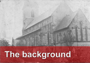
When the Church was built, the village was often referred to as Waterhead Mill: one of the first gravestones in the graveyard at Waterhead Church. Look at the third row of text after the heading.
Waterhead still retains an air of slight separation although in truth it is today encircled almost entirely by other districts of Oldham: this one-time village is now juxtaposed with parts of Greenacres, Littlemoor, Watersheddings, Moorside, Lees, Austerlands and Scouthead.
It also has glorious views over the hills of Saddleworth, and abuts the natural splendour of the Strinesdale nature reserve. (‘Strine’ is an old English word for ‘boundary’, so the Strinesdale was an ancient boundary between Lancashire and Yorkshire.)
Until 1625, the village was surrounded with open moorland farmed in common. It was also a source of peat for fuel as remembered in the name of nearby Lower Turf Lane. Enclosure to form settled fields resulted in a pattern of large, regular strips of land that can still be made out above Austerlands.
The earliest actual mention of Waterhead was Watergate Mill in 1648; and is mentioned in a document dated 1654 that says ‘that Water Corn Mill commonly called ‘Watergate Myll’ (where the suffixes ‘–head’ and ‘–gate’ are equivalent and both indicate a mill-race). This mill could be identical with a ‘Watergate’ mentioned in an earlier document of 1468; an eighteenth-century record relating to a sale of land indicates that the water in a mill gate fell a distance of 27 feet, which was sufficient to power a wheel of diameter 25 feet.
Two centuries ago, the dominant industries were cottage industries and coal. Small-scale animal husbandry also played a part. There were 23 commercially-significant coal pits in the locality when the Church was built, including larger workings at Count Hill, Paulden, and Sholver. The Paulden pit — ‘Paulden Wood’ to the east of Waterworks Road— was about 300 yds from the current Church. It was most active in the 1840s when the colliery employed eighty-three men and many boys. It closed in 1922.
Evidence suggests a much smaller pit on the land between what is today Brideoak Street and Huddersfield Road, before Mill Bottom, and another just off Cobden Street which supplied Brideoake’s Daisy Hill Mill (built in 1803) and was still supplying coal to Wareing’s ‘Coppice Mill’, which was built in 1924. In fact, there were two even smaller pits situated side-by-side to the south-east of the Church: ‘the colliery’ on what is now New Royd Road and between The Colliery and Water-works Road. These pits and workings may be responsible for some of the subsidence at the north-east corner of the Church graveyard.
Being too poor for agriculture, the land between Oldham and Waterhead was cheap and therefore ideal for industrial entre¬preneurs when the Industrial Revolution reached this part of Lancashire. Like many northern towns, Oldham grew fast. Water¬head and indeed the whole of the Oldham area soon experienced extensive industrialised growth from the late eighteenth century into the early years of the twentieth.
Waterhead village was the site of considerable industry and commerce. Much of that growth centred round mills processing cotton and making cloth. By the end of Victoria’s long reign, as much as 10% of the world’s cotton was processed in Oldham. These mills dominated the lives of Waterhead people. Most of the Waterhead mills were built on what today would be called green-field sites. Three such were the Holroyd (which was replaced by the Orb); and the Orme and the Majestic which were both owned by The Lancashire Cotton Corporation. The Cairo and the Majestic were two of the last to be built; both were erected in 1903. The map below/above shows a small reservoir (or ‘mill lodge’ as it was called locally) on the western corner in front of the new Waterhead Church. The lodge was built to store water in case of fire at the mill. This mill lodge would have belonged to the mill on whose land the Church was built. The water was drained soon after the Church was built, presumably to protect young pupils at the Church school.
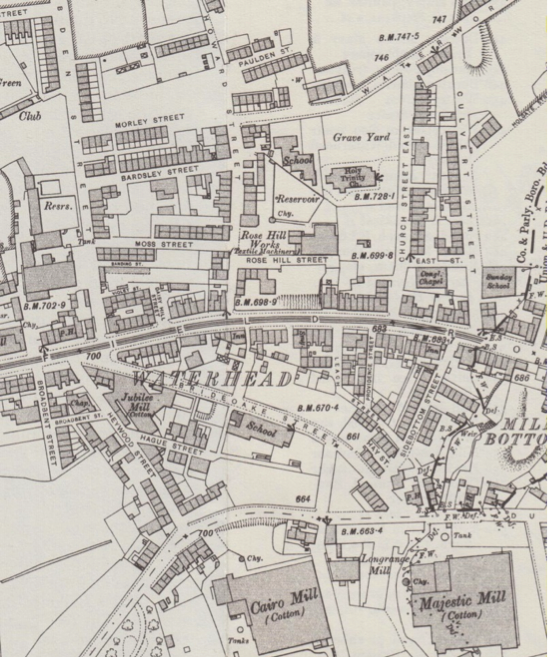
A map of Waterhead village in 1907.
All this commerce required a transport infrastructure, so the Manchester–Huddersfield–Wakefield turnpike road was upgraded to become the major packhorse route into Yorkshire. It was improved in two stages: an Act of Parliament in 1735 funded the extension of the road as far as Austerlands and, 23 years later, a further Act funded the road’s journey into Yorkshire. The road has since undergone several major changes in route to yield a gentler climb and alleviate the camber. It is now the A62 Huddersfield Road.
Several local pubs date from about this period. For example, the Coach & Horses was built in 1821 and the Peels Arms on Den Lane in 1833. At Waterhead Mill Bottom, the landlord of the Gardener’s Arms built the Bull’s Head in 1823 when the new road across the Pennines was built. It still remains.
As Waterhead village expanded, many of its inhabitants believed their village needed a new church. The Congregational Church already had two local meeting places, in Green¬acres and later in Spring¬head. Further Congregational services commenced in local cottages in 1837; and Waterhead chapel was built in 1870 on Church Street.
Other churches in Waterhead
Many chapels were built in Waterhead during the nineteenth century but none survives today.
The Congregational Church Greenacres Congregational Church founded a daughter Church in Waterhead in 1839. A new chapel was opened on Providence Street in August 1847. A further branch connected with the Union Street Church opened in May 1864, and another on Church Street in 1870 at a cost of £220. The latter was the last to close when it was eventually replaced with shops in the mid-1970s.
The Methodist Church The Waterhead New-Connexion Methodists erected a chapel on Spring Hill in 1838 which closed in 1976. The Primitive Methodists built a chapel on Heywood Street in 1832, which was closed in 1970 to make way for sheltered housing.
Watersheddings Wesleyan Methodists opened in the early 1870s. After amalgamating with the Waterhead Chapel, it moved to a new building in Ripponden Road known today as East Oldham Methodist Church.
